How do we know if we are “due” for the Big One?
Today is our Earthquake Anniversary. Three hundred and twenty-one years ago, at 9pm, our last Big One hit the west coast of North America.
Every year, my blog post marking this anniversary (which I wrote back in 2010) gets a lot of attention. That article outlines both what scientists know about the Cascadia subduction zone as well as how we know it – and it talks about what to expect when our next giant earthquake-plus-tsunami event hits.
 http://en.wikipedia.org/wiki/Image:JuandeFucasubduction.jpg, Public Domain, https://commons.wikimedia.org/w/index.php?curid=2477698)
Pretty much every year, I get questions from readers about when, exactly, the next Big One is going to come, and whether we are “due” or “overdue” for it.
Predicting earthquakes is still not really possible – the best we can do right now is study when past ones occurred so we know how often they happen, on average, and calculate probabilities.
Last year, however, I made a new friend on Twitter: someone who has a lot of new information about this. Jay Patton is an Engineering Geologist at the California Geological Survey, Seismic Hazards Mapping, Tsunami Unit. Part of what he does there is figure out those earthquake recurrence intervals.
Jay retweeted my article about the earthquake anniversary, so I followed him. A few days later, he posted a really interesting map (reproduced below), which explains a lot about scientists’ current understanding of recurrence intervals of Cascadia subduction quakes. It comes from a paper that Jay is a co-author of (Goldfinger et a., 2017: Marine Geology, v. 384, pp 4-16, 17, 25-46), but he modified the map slightly for Twitter.
I was really intrigued by this map (my PhD is in structural geology, but I have been out of the research world for quite a few years) – so I asked Jay a few questions about it. This blog post is essentially an expansion of what he explained to me via Twitter.
Before I go there, though, I just want to get a few definitions and concepts out of the way – to make sure we are all on the same page. (If you are not clear about what a subduction zone is, and why ours is here, then please check out my earlier post first).
What is a fault?
A fault is any fracture in a body of rock along which there has been movement. That movement can be at any scale: from a few millimetres to thousands of kilometres. Most faults are no longer active (their last movement millions of years ago). Some faults are still active. That does not mean that they are moving this second, but it means that pressure is building up across them, and they will move again at some point.
What is fault displacement?
The displacement is how much a fault moves when it slips. Faults do not release all of their slippage at once – rather, they break periodically, slipping a little bit each time (each time it slips is one earthquake). The total displacement of a fault is the total amount the two sides have moved relative to one another over time. We also talk about the displacement during an individual earthquake event, which can be from millimetres up to several metres. (A displacement of metres all at once would generate a very large earthquake).
What is a recurrence interval?
The recurrence interval is how often a specific fault slips on average – in other words, how often there is an earthquake along it. Calculating the recurrence interval is one of the most challenging things for geologists to estimate, because we cannot predict an exact timing for that. That’s why recurrence intervals are expressed as averages and/or ranges and/or probabilities.
What is a fault rupture?
The rupture is the part of the fault that actually breaks. This is a super important concept to get, if you want to understand Jay’s’ map.
Let’s take a large fault zone like the Cascadia subduction zone, which is nearly 1000 km in length. It is possible that the whole fault zone might break at once. But it is also possible (and more likely) that only one section of the fault breaks. The whole fault is there and exists – but only one section of it slips in any one earthquake. The part of the fault that breaks, or slips, during one earthquake is the rupture length. The next earthquake may rupture along a different part of the fault.
Jay’s map covers the length of the Cascadia subduction zone:
The surface trace of the subduction zone lies offshore, extending from Vancouver Island down to northern California. It is basically the region shown in red.
The orange lines that Jay has drawn to the right of the map represent different possibilities for which parts of the fault might rupture. The yellow writing represents the recurrence interval for that fault segment. The recurrence interval is expressed both as an average (e.g., in the north, where I am, it breaks on average every 480-505 years) and also as a range (it can be as little as 110 years and as much as 1150 years).
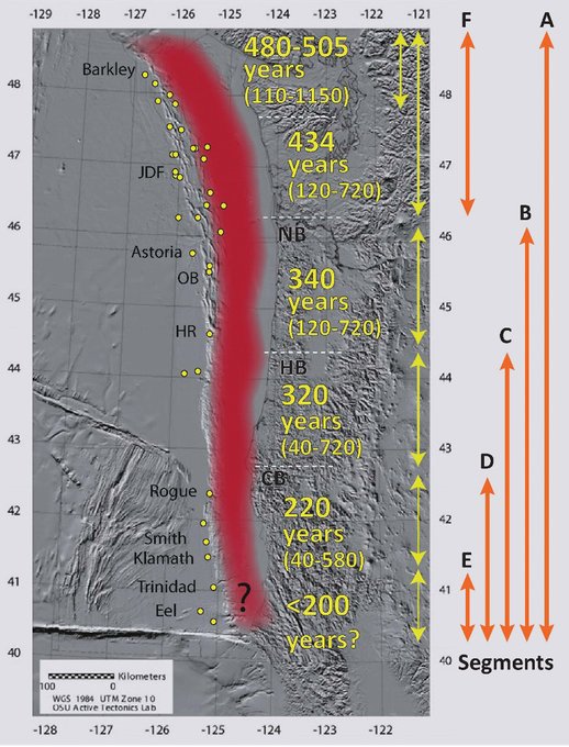
So the line A represents the entire zone rupturing in a single (huge!) earthquake event. All of the other lines represent partial ruptures – only a portion of the fault breaking in any one event. (Which would still be a pretty big earthquake!).
However, what Jay explained to me, and what I find extremely interesting, is that the northern part of the fault zone behaves very differently from the southern part. Look at the southern segments: C, D and E. Their average recurrence intervals are very small (320 years or less) compared to the northern segments (average recurrence interval 434 years or more).
This is because the southern segments all share portions of the subduction zone when they slip during an earthquake. So the southernmost segment, E, might slip and cause a moderate earthquake. But if the next one to the north, D, slips, the fault will also slip along the segment E portion. For that reason, E slips more often – both on its own schedule and when D goes and triggers E.
Same thing for C: if it slips, it also slips in the same part of the fault as for segments D and E.
And B slips in the region of segments C, D and E. Therefore the earthquakes down at the south end are more frequent. As Jay puts it, “For most earthquakes, the southern part of the fault slips.”
In contrast, up in the north, segment F is doing its own thing. It mostly does not slip when the other parts of the fault slip (unless it is a total rupture along the entire length A). Earthquakes along segment F are therefore much less frequent – which means that they may be more powerful, because the stress across the fault is not being released as often.
So, what does that mean: are we “due” for the Big One or not?
Well, like we said, the last Big One was on January 26, 1700 – so 321 years ago. Here in the north, where I live (on Vancouver Island), these big earthquakes occur on average every 480 to 505 years. If earthquakes occurred like clockwork, right on time according to their averages, you might breathe a sigh of relief: “Phew, we have another 160 years!”
But that is not how they work! An average means just that – it is an average, with a 50% chance of the quake coming “early” and a 50% chance of it being “late.” Look at the range on Jay’s map: the quakes here in the north can be as little as 110 years apart (or as much as 1150 years apart). Looking at it that way, with our last Big One 321 years ago, we are most definitely within range.
So our Big One could come tonight – or it may be centuries away. We cannot predict when the next Cascadia subduction zone earthquake will happen, but we do know that it will definitely happen, and that it will be huge. This doesn’t mean that you should panic, but you should check in with your own community’s Emergency Preparedness program so you know how to prepare for it.
Jay Patton keeps track of earthquake reports around the world, and he also explains a lot of the more technical stuff on his site: you can find him here. And if you like what I have here on my site, or want to keep informed about my current exciting projects and adventures and speaking engagements, please sign up for an occasional email update on my Contact page. (Don’t worry, I respect your privacy and I will never spam you!)

great post, I feel like I learned something new today about this whole subject. Very clear and concise message. side note – it is also Australia Day, which commemorates the arrival of Europeans in Australia on 1778. So the last big earthquake on the north end was 78 years before. pretty neat!
Thanks Brian!
And you know I’m dual Australian, right? My first Australia Day *in* Australia was somewhat inauspicious, though… my first car accident. Oops. (And only, BTW).